The standard Tuesday OAC meeting runs like this: the mechanical super says he's at 78% on Level 4. The structural PM says steel is essentially done on 5 and 6, just waiting on a few connection plates. The owner's rep writes everything down. Nobody pushes back because nobody has a number that contradicts anything.
Two weeks later, the schedule slip that was already in motion becomes visible when the electricals can't rough-in because the framing isn't actually done. At that point you're managing a delay, not preventing one.
The gap between what gets reported and what's actually happening on site isn't a people problem — it's a data-latency problem. Weekly verbal status calls are a sampling mechanism running at a frequency too low to catch the trajectory before it becomes a problem.
What "percent complete" actually means in practice
Ask three project managers how they define "percent complete" for a structural steel package and you'll get three different answers. Some base it on installed connections versus total connections in the IFC model. Some go by tonnage. Some go by floor level finished divided by total floors. Some, honestly, go by how confident the sub sounded on the phone.
None of these are wrong, exactly. But they're all calculated differently by different subs on the same project, and almost none of them are independently verifiable in real time. The percentage that ends up in the weekly report is a negotiated number — shaped partly by actual progress, partly by what the sub thinks the GC wants to hear, and partly by what makes the payment application look clean.
This isn't cynicism. It's just how reporting works when the person being measured is also the person generating the measurement. The incentive to report favorably is structural, not malicious.
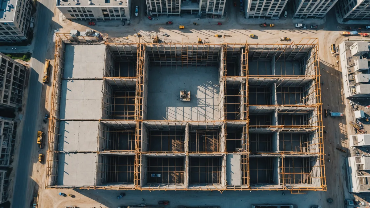
What drone imagery actually changes
A drone flight over a 12-floor commercial tower takes roughly 25 minutes if the site has FAA Part 107 clearance and a competent pilot. The output is a dense photogrammetric dataset — tens of thousands of overlapping images that can be processed into a georeferenced point cloud and orthomosaic within a few hours.
The point cloud doesn't negotiate. If Level 5 structural steel has 61% of its IFC elements represented in the scan, the number is 61%. Not 78%, not "almost done." The comparison is made against the BIM geometry directly — the drone data is registered to the coordinate system of the model, and elements are checked against their expected position and geometry.
The value isn't that the technology produces a "better" percent complete. It's that it produces an independent one. You now have two numbers: what the sub reported, and what the site looks like from 120 meters. When those numbers diverge significantly, you have an actionable question to bring to the next coordination meeting — one backed by images, not impressions.
The schedule gap detection mechanism
Consider a 22-floor mixed-use project with a CPM schedule calling for structural steel completion through Level 14 by the end of Week 16. A drone scan on Thursday of Week 14 shows Level 12 at 94%, Level 13 at 71%, Level 14 at 38%. The sub's status report from Monday said "on schedule through Level 14."
That's not a scandal. It might be that the sub is counting installed pieces differently from what the BIM check is counting, or that there's a genuine data gap in the scan coverage on Level 14's north face. These things happen. But the divergence triggers a specific question: what's the actual definition of "complete" on Level 14, and does that definition match what the CPM schedule requires for downstream trades to mobilize?
If the answer is "we're 2 days behind on connections but the crane can still start the Level 15 columns Monday," that's a real answer you can plan around. If the answer is "we thought Level 14 was further along than it is," you've just bought yourself 10 days of recovery time that you wouldn't have had if you'd waited until the OAC.
The coverage problem — what scans miss
We're not saying drone imagery gives you complete site visibility. It doesn't, and that's an important caveat.
Photogrammetric surveys from above are strong on horizontal work — slabs, framing completion by floor, roof deck, exterior cladding panels. They're weaker on vertical interior work happening behind weather barriers or inside MEP shaft spaces. If your critical path runs through plumbing rough-in inside a closed shaft on Level 8, a drone isn't going to tell you much. You still need the field superintendent walking those floors.
Ground-level imagery from site cameras or walk-throughs fills part of that gap, but the registration to BIM is harder and the coverage is less systematic. The honest picture is that drone-to-BIM comparison is most valuable for structural and envelope phases, and less reliable for MEP rough-in and interior work — which, of course, is often where the real schedule risk lives in the mid-to-late stages of a commercial project.
Frequency matters as much as accuracy
The weekly status call has a 7-day cycle. By definition, you learn about problems that have been developing for up to 7 days before you hear about them, assuming the sub is reporting promptly. In practice, subs often don't flag a developing issue until it's confirmed — which adds another week. So you're running 10-14 day discovery lag as a baseline.
The way to close that lag isn't to have more meetings. It's to scan more frequently. Twice-weekly drone flights over active structural and envelope work costs a few hundred dollars in pilot time and cloud processing. For a project where one day of critical-path delay might cost $15,000–$40,000 in general conditions, the math isn't complicated.
What changes isn't that you catch every problem immediately — you don't. What changes is that you're running on a 3-to-4-day discovery cycle instead of a 10-14-day one. The delay that was going to cost you two weeks now costs you three days because you had enough runway to redirect resources before the impact cascaded.
Making the numbers useful in the room
The weekly coordination meeting still happens. The 3-week look-ahead still gets reviewed. The value of having image-derived completion data isn't that it replaces those processes — it's that it changes the quality of the conversation.
When you walk into an OAC with a floor-by-floor completion chart derived from Tuesday's scan, the conversation shifts from "where are we?" to "these three areas are behind schedule and here's what we're doing about them." Subs who would have reported optimistic numbers now know you have an independent baseline. That changes the incentive structure around reporting without anyone having to make it adversarial.
The most underrated benefit isn't catching people out. It's that subs who know imagery is running tend to report problems earlier and more accurately, because they're not managing the owner's perception of their progress anymore — they're managing actual progress. That's the cultural shift worth paying for.
That said, getting there requires a few things: a project-wide BIM model that's actually current and georeferenced correctly, a consistent drone flight schedule that produces comparable datasets scan-to-scan, and someone who can close the loop between the deviation data and the CPM schedule before the OAC. Those aren't trivial requirements. But for a $50M commercial project in the structural phase, they're achievable with modest effort.